")


Louvigny : promenade Henri IV
- on foot : 2h50 - Difficulty Difficult
- Distance : 14km
- Vertical rise : 200m
- Public : Sportifs
Itinerary
Step 1 :
Depart from the church car park Head south along the Route de Saint-Jacques de Compostelle (GR65) towards the Moundy farm.Step 2 :
At the crossroads, turn left along the crest path to the picnic tables at the summit.Step 3 :
Follow the path to the Chapelle de Beyrie.Step 4 :
At the main road, turn right as far as the silo. Cross the road and take the tarmac path to the bridge over the Riumayou (a tributary of the Luy de France) and the Ninet mill.Step 5 :
At the top of the climb, turn left (along the PR4B path) as far as Cousquet.Step 6 :
Head for the picnic area with its panoramic views. Alternatively, turn left onto the dirt track and then the forest slope leading to the RD270, where you turn left onto the RD32 and then right towards the Luy de France bridge.Step 7 :
At the start of the hill, cross the road carefully towards the tarmac road on your left (route de Vignes). At Lacarrère, turn left onto the dirt track until you come to a gravel path (Cabirou). You are now on the GR65 path, which you will follow over the Louvigny mill bridge as far as the town hall and church.
Don't miss
- Panoramic view of Mialos (Panorama)
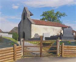
 Beyrie chapel (Rural heritage)
The 12th-century chapel of Saint André, also known as the Chapelle de Beyrie. This building has a west-facing bell tower. Stonemasons' marks can be seen on the north buttress. The chapel was extensively altered in the 19th century. Inside, there is an embossed red terracotta floor, a limestone baptismal font and a sandstone stoup dating from the 15th or 16th century.
Points to note :
- Attention sur la RD32 (;)
Nearby routes

Louvigny : promenade Henri IV
The tour offers a glimpse of 10th-century seigneuries such as Louvigny. This…
LOUVIGNY
Louvigny : promenade Henri IV à VTT
This trail offers a glimpse of 10th-century seigneuries such as Louvigny, which…
LOUVIGNYNearby accommodation

Ferme La houn de Lacoste
"1 suite in a béarnaise style house, in heart of active farm.…
LOUVIGNYAgenda
Useful links


