


The Arles route on the GR® 653 stage 3
- on foot : 5h10 - Difficulty Average
- Distance : 19.7km
- Vertical rise : 45m
- Public : Sportifs
Step 1 :
Bridge of the Casteyre With your back to the entrance to Sainte-Foy de Morlaàs church, turn left into rue des Cordeliers (towards Pau). Drive alongside the stadium and then, at the traffic lights, continue straight on for 100 m; go up the one-way Rue des Frênes, leaving the D923 on your left. At the top of the only hill of the day, before rejoining the D923, turn right into rue Capdessus. After a few houses, cross the Route de Maucor at the lycée (pedestrian crossing and bus shelter) and follow the road to the right. Very quickly, at the corner of the sports ground, turn left onto a tarmac road. After the secondary school annexes, continue straight ahead on the country lane. A track takes over from the tarmac; continue straight down the main forest track to reach the Pau plain. At the bottom, at the T junction, follow a gravel track to the left for 800 m. When you come to a bend in the road, follow the tarmac to the right. At the next crossroads, turn left onto the Chemin de Higueres for 30 m, then right onto the (tarmac) Chemin de Casteyre. After the last houses (organic farms), a track continues along the road. At the T-junction, take the left-hand path over the Casteyre bridge.Step 2 :
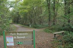
Crossroads of Salié, Roumieu and Ossalès 300 m further on, leave a grassy track in front of you to keep to the gravel track that bends 90° to the right. The Morlanné track (tarmac) takes over and brings you to a T-junction: go left for 50 m, then turn right (Larricq bus shelter). Quickly ignore a cul-de-sac of the same name on the right and the accesses to the housing estates, keeping the main road between the houses. At the end, carefully cross the D222 (traffic) and continue straight ahead along the (tarmac) Morlanné lane. 800 m further on, cross another road (be careful) and walk straight ahead through the villas on the Pont Long moor. At number 1314, at the four-way junction (8 km / 2h00), turn left onto the Chemin de Petit. 150 m further on (T), turn left again, then right at the metal barrier. The track runs alongside fields facing the Pyrenees (leave the side paths on either side). At the end of the straight, the gravel path veers left, then right, and crosses a stream. After 100 m of tarmac, fork right onto a gravel path towards a riding school. In front of the entrance to the buildings, veer to the right and follow a path along the fence into the Bastard national forest. Once through the gate, turn right onto the wide, straight path (3rd alleyway east) for 1.2 km. Relaxation area and water point (information), at the junction of Salié, Roumieu and Ossalès roads.Step 3 :
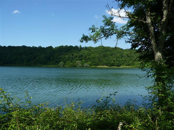
Lake Carolins Here, take the tarmac road to the left (Compostelle is given as 930 km away...) for 250 m, then turn right onto the 2nd allée Ouest (or Pichadet), at the corner of the forest house. At the end of the lane, without going through the wooden barrier, follow the path to the left, along the edge of the wood. After a duckboard, cross the 1st lane to the west and, of the two paths opposite (bench), choose the one on the right. Continue right into the woods until you reach a bend in the road. At this junction, take the gravel path on the left (metal barrier); it leads to a bridge over the A64 and the Pau ring road. On the other side, keep to the circular gravel track alongside the racecourse. Near the pediments, go through the wooden chicane and join the Avenue du Cami Salié. Follow this road to the right, staying on the pedestrian/cycle path under the trees. After a chicane, cross the racecourse car park, staying on course. Cross the junction with the D834 (14.4 km / 3h40), taking care to keep out of the way of traffic (pedestrian crossings), and continue straight ahead along the Chemin Salié (towards the ZAC du Perlic in Lons). Avoid the next roundabout by turning right at a pedestrian crossing, then continue straight ahead along the avenue's pavement. Leave Boulevard Blériot on your left and walk straight on towards the last houses. When the road bends at right angles between two fields (signposted Lons exit), leave the tarmac for the gravel path on the left. It runs alongside a few villas and then curves 90° to the right. Walk straight ahead until you find a footbridge over the Ousse des Bois stream. Shortly afterwards, walk alongside Lac des Carolins.Step 4 :
Lescar Lac des Carolins (16.9 km / 4h25). 100 m after the entrance to the lake, turn left at the crossroads (pedestrian walkway) and, at the foot of the water tower, take a path on the right; it runs in a straight line between the houses of a housing estate. At the end, turn left and then immediately right through the villas (chemin du Cam Loung). At the stop sign, walk straight on to rue Maurice Coustau. When you reach the dual carriageway, continue straight on until you come to a give-way sign: cross the Avenue de Plaisance and follow it to the right (left-hand pavement). Then turn left into rue du Vallon; take the second turning on the right very quickly. Cross the cemetery car park diagonally to find a footpath running alongside it on the left. Near the residence, turn left down a path or flight of steps to a green footbridge over a stream, and climb back up to the other bank. The Labanère path leads (after the porch) to a crossroads with an old well, Place Croix de Mariotte. Turn right after 20 metres and then immediately left into rue Henri Rozier. After a bend, it heads towards Place Royale de Lescar (with views of the Pyrenees) and the forecourt of the former Notre-Dame de Lescar cathedral.
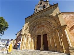
 Notre-Dame de Lescar Cathedral (Heritage)
With its classical medieval architecture, Notre-Dame de Lescar cathedral is the imposing remains of a fortified bishopric built in the 12th century. Under the apse are buried the ancestors of Henri IV, the future King of France. On the outside, the many sculpted decorations, capitals and modillions are well worth a look. Inside, the highlight of the building is a Romanesque mosaic with oriental overtones on the floor of the apse, depicting hunting scenes.
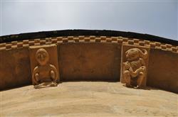
- The crossroads of Bastard Wood (Nature site)
Béarn has always been crossed by generations of travellers, merchants, pilgrims and shepherds. As travelling on foot was the only way to get from one part of the region to another, many 'routes' were created over the centuries. Pilgrims on the Cami Roumieu (the route to Santiago de Compostela), peddlers on the Cami Salié (the salt route from Salies-de-Béarn to Toulouse) and shepherds on the Cami Ossalès (the transhumance route from the Ossau valley) crossed paths at this very spot.
 (Heritage)
Nearby routes

Les balcons du Béarn - N°12
A very pleasant loop through deep Bearn which offers a privileged view…
MORLAAS
De Morlaàs à Lescar
While this stage links two masterpieces of Romanesque art, the church of…
MORLAAS
Balade patrimoine à Morlaàs, capitale historique du Béarn
Heritage walk in Morlaàs, the historic capital of Béarn Situated to the…
MORLAASNearby accommodation

Hôtel-Restaurant Le Bourgneuf
At 10kms from Pau, in the center of Morlaàs, the hotel/restaurant Le…
MORLAAS
La Hourquie café
Not far from Pau, in the shade of the wooded Hourquie square…
MORLAAS
Hôtel-Restaurant L'Amandier
L'Amandier is located at about 10 kms North-East from the city of…
MORLAASAgenda
 15Jul
15Jul
 15Jul
15Jul
Introduce your child to the magical world of butterflies with a story about insects and flowers. After this moment of poetry and observation, the children will learn the ins and outs of…
MONTARDON 15Jul
15Jul
An ancient message is hidden in the stones of the Sainte-Foy church in Morlaàs? Can you find it? "Mission Sainte Foy : le code du chapiteau" invites you on a playful, mystery-filled…
MORLAASUseful links


